

The late Marie Petuh was not only a ‘forever’ member of the Naturalists’ Club of Broome County, but she was also one of the early participants in the Franklin Mt. Hawkwatch in Oneonta. The Delaware-Otsego Audubon Society has an ongoing program to capture and fit Golden Eagles with GPS transmitters to learn their winter locations and migration routes. Naming rights for captured birds go to supporters of the program, and on January 14, 2016, a female Golden netted in Delaware Co. was named Marie by Kay Crane of Walton, a long-time friend and birding companion of Marie Petuh.
A nestling in 2013, Marie will be a full adult next year. It is unlikely she bred this past summer and it is not known if she is with any other Golden Eagles. It is apparently difficult to determine if the clusters of data points on the summer map are nesting vs feeding locations.
Unlike her petite namesake, this Golden is reportedly a fairly large eagle weighing 12 lbs. with a 7 foot wingspan.
Mike Clark, NYSDEC R4 Wildlife Manager, has just fitted Marie with her tracking device.” width=”614″ height=”410″ /> Mike Clark, NYSDEC R4 Wildlife Manager, has just fitted Marie with her tracking device.
According to Tom Salo, this eagle likes carrion. She has fed numerous times very near highways. She spent a week along State Route 17 near East Branch. Other tracked eagles avoid roads for the most part. The past 2 winters Marie spent a lot of time where a coyote hunter puts out road killed deer as bait. Probably not a good location as the deer carcasses may well have been shot with lead, which is frequently lethal to eagles. Marie has spent very little time at that formerly baited location this season, staying mostly north or west of it.
Incidentally, the data from the GPS transmitter is received via the cell phone network, so once a bird goes far enough north in Canada and out of cell phone range, no more info is received. However, the unit stores the summer’s data and downloads it when back in range in the fall. According to Andy Mason, Marie came back into cell phone range in southern Canada in mid-November 2016, which allowed download of data of her movements since she went north the previous spring.
Special thanks to Andy Mason and Tom Salo for providing the information and photos for this article. More info on DOAS’ Golden Eagle research is available at http://doas.us/research/golden-eagles/.
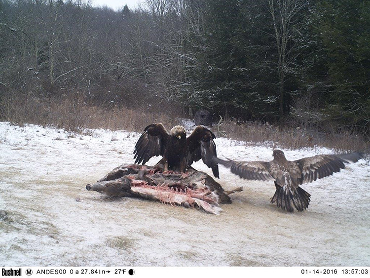
Photo of Marie just before capture on a deer carcass with an immature Bald Eagle nearby that needed to clear off before the capture could be done.
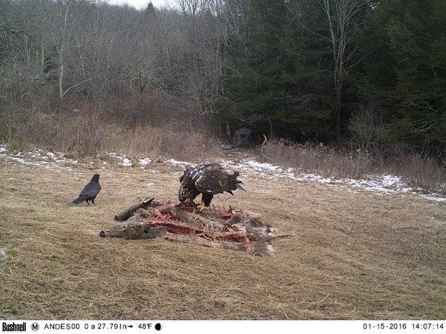
Photo of Marie revisiting the capture site the following day and her transmitter can be seen. Marie remained in the area where captured and returned to the same trap site several times, seemingly not traumatized by the experience.
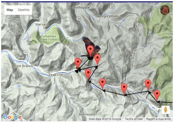
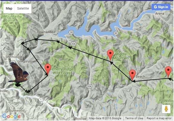
Marie’s flight path in the days after her release in southern Delaware County. January 2016.
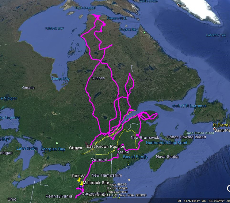
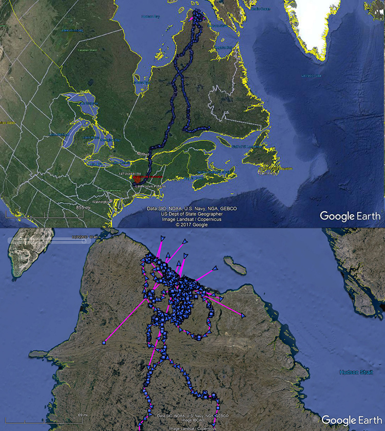
Her last position on this map is near Quebec City. The route on the Gaspe Peninsula and figure 8 into mid-Quebec are from the spring before she headed north to Hudson Strait. Since this map, she continued to slowly move westward to near Montreal.
Above is Marie’s location in December 2016 after spending some time in the Adirondacks on her way back to the Catskills from Canada.
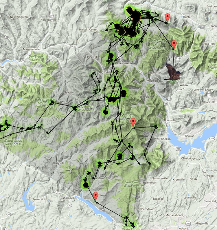
Marie’s position on December 12, 2017 east of Phoenicia in the mid-Catskills. After this date, she went west into PA. She spent a few days there and then went right back to the eastern Catskills.
A map of her locations shows Marie recently visited the location where she was in the Summer of 2016.