


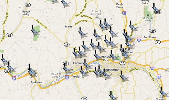
Click on the map to view the best birding sites of Broome County and the surrounding areas.
Airport Road North Flood Control Dam
Located 2.9 mi. North of the traffic light at E. Maine & Lewis Rds. to a parking area on the left between two houses (NYSEG 3104 utility pole marks the spot). Walk the dam head embankment directly west (mowed courtesy of the neighbors). Expect to see or hear least flycatcher, cedar waxwing, red-eyed vireo, rose-breasted grosbeak, wood thrush and indigo bunting. Wildflowers include swamp milkweed, clintonia, pyrola, bunchberry, jack-in-the-pulpit, wood strawberry, painted trillium, Joe-Pye-weed and blue vervain. There are no formal trails; leaving the dam head is a rough trip to a footpath that leads on the west side of the pond through the woods. You must return the same way.
Airport Road South Flood Control Dam
Entrance is off Lewis Road between the church and Ametek. Turn in and park across from the small brick building. Walk past the gate and follow the level truck road .5 mi. to the pond. This path has many wildflowers along it in season including evening primrose, deptford pink, moth mullein and bergamot; at the pond look for water plaintain, hoary allysum and monkeyflower. Both egresses converge near the pond but to continue from either direction you will have to ford ankle-deep water in most seasons. The walking paths east of the embankment along the woods are level or slope gradually; however, they do not circle the pond and you must return the way you came.In June and July house wren, warbling vireo, b. kingfisher, blue-winged/yellow warblers, cedar waxwing, willow flycatcher, great blue/green-backed herons, e. phoebe, and nesting mallards have been seen.
Apalachin Marsh
The Naturalists’ Club was instrumental in helping save this 50 acre wetland from destruction when NYS Rt. 17 was being built. It is now managed by Waterman Conservation Center; there is a level woods trail leading to the marsh where a blind allows you to observe the area from concealment. Bring bug spray if coming in the summertime. Located in Tioga Co., the marsh lies between the east & west-bound lanes of heavily-traveled NY Rt. 17 and is reached by going west on NY Rt. 434 (Vestal Parkway). After 1.4 mi. from the traffic light at Pennsylvania Ave. in Apalachin, park well off on the highway shoulder on either side. In the gully paralleling the road on the north, there is a gate in the chain link fence that borders the highway right-of-way. Go through the gate, shutting it behind you, and follow the path through the culvert pipe under Rt. 17. Bearing to the left will lead you to the marsh and the observation blind (follow the yellow markers).
Visit Apalachin Marsh’s website
View this location on the map
Aqua-Terra Park
The is an undeveloped Broome County park. A parking area and small pond are South of Maxian Road and a larger pond is located across the road. The swampy and brush lower habitat provides a good mix of warblers and you can find deep woods birds by crossing the small creek and hiking up the trails. A hike straight up the ski slope is quite strenuous.
Arnold Park
Most of this 100-acre park was given to the town of Vestal by “Pop” Arnold and is heavily used by town residents for recreational activities during the summer; however, it also includes a fitness/nature trail which leads into the quieter portions of the park, up through the woods, to come out in a clearing at the top of the hill where you will be treated to a spectacular view of the valley area.
Bailey Hollow Flood Control Dam
The lake at Bailey Hollow is a pleasant jaunt in beautiful surroundings. A few years ago an errant great egret was surprised on the water; on other more ordinary visits indigo bunting, savannah sparrow and e. wood pewee have been seen in summer. An October trip included red-br. nuthatch, rough-legged/red-tailed hawks, brant, mallard, pied-billed grebe and great blue heron. Wildflowers seen in spring include hepatica and ladies’ tresses orchid.
To reach Bailey Hollow, take NY Rt. 26 north from Endicott; past Maine turn left at the Y on to Nanticoke Rd, then in .2 mi. left on Tiona Rd. Proceed 1.5 mi. to a left turn on Bailey Hollow Rd. After .7 mi. you will see on the left the county gate barring the road which leads down to the pond. Park along the shoulder and walk in about .5 mi. Also an old trail leads from the road west of the parking space through the woods down to the pond. From here bushwhack to the dam head and the eastern egress.
Binghamton University Nature Preserve
Located on the southern border of the Binghamton University campus, the preserve has a six-acre pond, swamp, mature woodlands and overgrown fields for a varied habitat thus resulting in a diversity of birds and small mammals. A boardwalk crosses the pond’s eastern edge and can be a focal point for a day or evening visit. Look for the resident beavers from here. There is also a complex network of trails (some marked well and others not) which can be utilized as fully as desired. Many wildflowers can be seen in spring including arbutus and laurel; trumpet honeysuckle along the pipeline trail, turtlehead and closed gentian bloom in September. Unique at the preserve is the spotted salamander living in the forest and migrating to the pond to lay eggs in spring. Small blacktop ramps were constructed along the through road to facilitate their movement up and down the curbs during this migration. Note that parking without permit may result in a fine when school is in session.
Visit the BU Nature Preserve’s website
View this location on the map
Boland Pond
This large pond is bisected by a roadway to the Broome County Highway Dept. complex. Park in the dirt parking area on the northern perimeter of the entrance. You can then walk past the gate along the paved driveway which runs through the pond. On the left is mainly open water; thick reeds fill the right side. During spring and summer you may see wood duck, mallards, common moorhen, great blue/green-backed herons, nesting marsh wren and swamp sparrow, e. kingbird and many red-winged blackbirds.
Interesting wildflowers grow along the driveway including monkey flower, hairy willow herb, broad-leaved arrowhead and dodder. Thomas Creek flows into the pond and through to the Chenango River; in early May spawning carp from the river roil the low water for an interesting spectacle.
Bradley Creek Flood Control Dam
Reach this pond off of Avery Rd. here are no developed trails. Walk down to the pond and through the woods as you please. Small pockets of wildflowers such as spring beauty, trout lily and red trillium are found in early May. Pileated woodpecker, house wren and spotted sandpiper are representative of the bird population in early spring.
Brick Pond
This 30 acre wetland was donated by Peter Ellis; the area is managed by the Waterman Conservation Center. Flooding in 2006 led to the water level being greatly reduced and this area has been under reconstruction for a few years. The area offers a marsh and forest habitat and should provide a good variety of species.
Brixus Creek (Sports Facility) Flood Control Dam
Softball games are played here in season but at quiet times a walk on the dam embankment and the fringe of the woods offers some possibilities for the naturalist.
Cannonsville Reservoir
This New York City water supply is our nearest location for observing wintering bald eagles. Adult and immature bald eagles have been seen here from late November till late March. Immature golden eagles have been observed during migration in both early spring and late fall. Many other species can be seen here both on the water and along the surrounding roads.
Cascade Valley State Forest
This area of approx. 750 acres in the town of Windsor has contained a generous sprinkling of woods birds in spring during a short stop in the parking area including ruffed grouse, ovenbird, chestnut-sided warbler and red-eyed vireo and could be worthy of further exploration for the adventuresome. There are no developed trails so take your compass if you decide to explore.
Chenango Valley State Park
Almost everyone in this area is familiar with this 3000 acre park, know to many of us as Lily Lake. A nature trail leads down between Lily and Chenango Lakes. Also the service road starting near the Nature Center lodge is an easy walk along the Chenango River. The woods in the Chipmunk Bluff camping area during early winter will often have pileated/hairy/downy woodpeckers, brown creeper, junco, tufted titmouse, common redpoll and white/red-br. nuthatches. In camping season, saw-whet owl was seen here. Also during winter great horned/screech owls, golden-crowned kinglet, ruffed grouse and red-tailed hawk are present. In spring there have been e. phoebe, warbling/red-eyed vireo, yellow-rumped/black-throated blue warblers, great crested flycatcher, veery, rough-winged swallow and sharp-shinned hawk plus the resident birds. White-tailed deer, chipmunk, woodchuck, and red/gray squirrels are commonly seen; river otter has also been spotted in early spring.
Cutler Pond
In the early 1900’s, ice blocks were cut from the pond during winter and then stored for sale in warm weather. The pond now is surrounded by residences but still affords some opportunities for birding and wildflower observation if a short trip is desired.
Past the baseball field on the right is a rough parking area where a trail leads through the woods along the pond. It will end at a private residence where you must then retrace your steps. Mid-May birds have included b. oriole, red-eyed vireo and great blue heron for a total of 20 species. Spawning carp provide an interesting spectacle. Many common wildflowers can be found on the banks and in the water. Much of the water surface in summer is obscured by a water shrub.
Dimmock Hill Road Flood Control Dam5
Park on Dimmock Hill Road and walk through the gate which immediately puts you on the dam embankment. Foot paths lead down to the water’s edge on either side of the dam head. Birds in early summer have included e. kingbird, b. oriole, field sparrow, veery, r-s towhee, grasshopper sparrow, e. phoebe, least flycatcher and others. Wildflowers seen are water plaintain, forget-me-not, blue vervain, swamp milkweed and rose mallow.
East Maine Rd. Flood Control Dam
Birds seen in late spring on the pond include mallard, great blue heron and killdeer. In the shrubs and mature forest along the power line skirting the pond were no. flicker, e. wood pewee, downy woodpecker, white-br. nuthatch and yellow/black-&-white and chestnut-sided warblers. Wildflowers in the spring include Canada mayflower, starflower, water arum and pink lady’s slipper.
Finch Hollow Nature Center
Finch Hollow is a natural history museum and outdoor education center operated by the Broome County Department of Parks & Recreation. There is an interpretive building and an adjacent wildlife sanctuary; the grounds feature a scenic pond, flood control dam, evergreen stands, open fields and easy-to-walk nature trails. Trails are open from sunrise to sunset all year. The interpretive building is open to the public Saturdays from Labor Day to Memorial Day, excluding holiday weekends, from 10:00 a.m. to 5:00 p.m.
Florence Shelley Preserve
This 357acre sanctuary, about 35 mi. south of Binghamton, was donated by Florence Shelley to The Nature Conservancy. It supports a variety of unusual bog plant species as well as cardinal flower, spring beauty and pink lady’s slipper in season. There is balsam fir in the forest, a rare species in northern Pennsylvania. A total of 79 bird species have been counted here in May including brown thrasher, hermit thrush, scarlet tanager, northern/Louisiana waterthrush, great horned owl, wood duck, chestnut-sided/bay-breasted/blackburnian/Cape May/Tennessee/magnolia/Nashville/Canada/black-&-white/black-throated green and blue warblers. Otter, mink, porcupine and bear frequent this serene and undisturbed wilderness.
Visit Florence Shelley Preserve’s website
View this location on the map
German Bog
This boreal acid bog is an ombrotrophic (rain-fed having no inflow or outflow of water) example of progression from a bog to solid land as it very slowly fills in. Until that happens it still gives anyone who ventures upon it the thrill of experiencing a quaking bog. PLEASE DO NOT TRAMP NEEDLESSLY ABOUT and DO NOT STRAY FAR FROM SHORE – YOU CAN BREAK THROUGH INTO DEEP WATER! Play it safe and stick to the edges of the bog. A rare dragonfly and the bog copper butterfly are found here in addition to many unique bog plants including fifteen varieties of sphagnum, narrow-leaved sundew & golden club (early July), rose pogonia & pitcher plant (mid-July), bladderwort, cranberry, bog rosemary, marsh St. Johnswort, cotton grass, grass pink and wild orchids including the white fringed (mid-August), purple and southern twayblade. All the plants are fragile and legally protected – treat them accordingly. DO NOT PICK ANY OF THE PLANTS – take your wildflower field guide to identify plants.
Glenwood Cemetery
This is an old cemetery in the town of Dickinson with mature trees and wild shrubs that offer birds protection and food. A creek winds through the area in a deep ravine.
To reach the cemetery go north on Glenwood Ave., Binghamton. Just past its intersection with Prospect St., the road passes under NY Rt. 17; make a right turn here almost immediately on True St. and follow parallel to the expressway until you come to the end of the pavement. Park along the shoulder and walk up the dirt road to the east of the creek. At the top of the hill, a flood control dam has been constructed and there is a small pond. You can continue across the dam head and bear left through the cemeteries and down to your car or you can return as you came.
Great Bend – Hallstead Pa Game Lands # 35
This is an area of 7611 acres of Pennsylvania game lands about 16 miles south of Binghamton that has proved very productive for birding in warm weather. Park along the road next to the headquarters building. You can walk around the building grounds and along the bushes. A little past the headquarters a rough dirt road goes south between it and the adjoining Little Egypt Creek and can be walked as far as you wish (or driven if you have an appropriate vehicle). Over 40 species can be compiled in early summer including b. oriole, turkey vulture, wood thrush, veery, red-br. nuthatch, green-backed heron, great crested/willow flycatchers, ruffed grouse, r-t hummingbird, rose-breasted grosbeak and black-&-white/chestnut-sided/yellow-rumped warblers.
Greenwood Park
Greenwood was Broome County’s first park and offers the usual park activities. Of interest to naturalists are the self-guiding nature/hiking trails. Birds found in the park during the nesting season are e. kingbird, Am. redstart, wood/hermit thrushes, ovenbird, junco, broad-winged hawk and black-&-white/black-throated blue and black-throated green warblers. In fall, the usual northern woods birds can be expected plus sharp-shinned/cooper’s/red-shouldered/red-tailed hawks and Am. kestral all have been reported, as well as great horned/screech and barred owls. On the lake in early May black tern were seen. In the southwestern corner of the park a stand of hardwoods from 150 to 250 years old includes beech, basswood, sugar and red maples, yellow and black birch and black cherry. In the spring marsh marigolds bloom along the creek. Other wildflowers seen are grape fern, pyrola and pink lady’s slipper.
Harold Moore Park
This small Vestal Park is used for recreational activities during the warmer seasons but its location on the banks of the Susquehanna River make it attractive to naturalists looking for water birds. A boat launching ramp leads down to the water from where the river can be scanned for some distance in both directions.
Hawks In Winter – Carr Rd
An excellent nearby area to observe wintering hawks is just over the county line north of Whitney Point into Cortland County. Observations can be made from the comfort of your car simply by means of a road tour.
It is possible to see rough-legged hawks (both dark and light phase) which have migrated down from their nesting range in Canada, as well as no. harrier, pileated woodpecker, red-tailed and sharp-shinned hawks. Northern shrike has been seen several times in this area and short-eared owls have been reported. In the nearby fields horned lark, snow bunting and common redpoll have been seen.
View this location on the map (Webb Road)
View this location on the map (Carr Road)
Hawkins Pond
This is a very secluded and basically wild area of outstanding beauty but it is suggested going there in a group. With several companions you will feel more relaxed to enjoy the birds and animals you may encounter. Denton Creek from the northwest is the main feeder of the 23 acre pond. During the warmer months of the year, wood/hermit thrushes, red-eyed/solitary vireos, r-s towhee, junco, indigo bunting, e. wood pewee, red-tailed hawk, mallard, great blue heron and black-throated green and chestnut-sided warblers may be found. Beaver and muskrat are often on the pond and otter have also been seen. In winter look for rough-legged hawk. The view from the overlook on Saxby Rd. affords a breathtaking panorama of the area. The adjoining Hawkins Pond State Forest of approx. 465 acres north and west of the park also has a trail system for your investigation. Avoid this area in the deer hunting season starting in late November.
Highland Park
This Town of Union park has the usual recreational facilities but also offers trails leading through stands of woods where spring wildflowers can be found in surprising abundance together with bird life until the park becomes active in summer. Along the nature/fitness trail masses of white trillium, wood anenome and barren strawberry bloom in early May. Over 35 species of wildflowers have been seen including pink azalea, clintonia, goldthread, miterwort, black cohosh, jack-in-the-pulpit, red trillium, dwarf ginseng and seven species of ferns including royal fern. Birds which have been seen in late spring before the crowds descend are mainly woods birds such as red-eyed vireo, ovenbird, e. wood pewee, white-br. nuthatch, black-throated green warbler and wood thrush.
IBM Glen
The IBM Glen is managed by the Waterman Conservation center is a productive spot for birding and nature study. Birds which have been seen in summer included blue-gray gnatcatcher, black-throated green warbler, wood thrush, ovenbird, red-eyed vireo and a rare visitor, a yellow-throated warbler in May 1988. Winter birds have been brown creeper, tufted titmouse, red-tailed hawk, golden-crowned kinglet, downy/hairy/pileated woodpeckers, white/red-br. nuthatches and cedar waxwing.
Masses of white trillium, wild ginger and fringed polygala bloom in early May. If you are adventuresome enough to walk up the glen, you can see fragile fern and liverwort on the rocky walls; laurel, hobblebush, blue cohosh, jack-in-the-pulpit and red trillium are among the large variety of wildflowers and ferns found here in spring.
Johnson City Flood Control Wall
This embankment along the Susquehanna River in Johnson City and Westover offers views of ducks and water birds as well as passerines that use the tall black willow trees bordering this stretch of the river. You can walk along the embankment itself or follow the paths through the trees and along the river. Black duck, mallard, great blue/green-backed heron, killdeer, ring-billed gull and various sandpipers may be seen if the water level is reasonably low. Other summer birds have included warbling vireo, b. kingfisher, song sparrow, osprey, cedar waxwing, common nighthawk (migration gathering in early September), tree/bank swallows, Carolina wren, field sparrow, e. phoebe and ruby-crowned kinglet. Beaver and muskrat have been seen. Along the river bank within season are Joe-Pye-weed, willow-herb, bindweed, turtlehead, hoary mountain mint and other wildflowers. To access this area park in the Home Depot parking lot and climb the embankment.
Jones Park
This is a relatively secluded and undeveloped park which presents excellent birding and wildlife viewing. It does include the Vestal Police Firing Range and, of course, you should avoid that section if it is found in use. The main mowed trail leads off to the right through the meadow skirting the woods on the left and then joins a woods road that leads you on as far as you care to venture. A rough path leads from behind the garage along the creek, crossing it several times before petering out. Another path leads north from the police firing range up a rough work road. During very early May the woods are carpeted with spring beauty along with wood anenome, wild ginger, red trillium, miterwort, toothwort, goldthread, several violet species, wood sorrel, white mandarin and dwarf ginseng. Silvery spleenwort, several types of lycopodia, jack-in-the-pulpit, indian cucumber root, golden ragwort and various ferns including grape are found in summer.
Ketchumville State Forest
This and Oakley Corners State Forest are located in Tioga County, and together make up the “Ahwaga Forest”. The habitat of Ketchumville is almost totally forest, consisting of about 500 acres, both coniferous and deciduous; there are a few trails on easy contours. As one might expect, the birds found here are those that favor deep woods and brush. Seasonal bird sightings have included wood/hermit thrushes, red-eyed/solitary vireos, ovenbird, junco, ruffed grouse, white-br. nuthatch, downy woodpecker and magnolia/black-&-white/black-throated green warblers. Blooming in the section accessed from Bailey Hollow Rd. are dog-tooth/yellow violets, red trillium, fringed polygala and arbutus in spring; butterfly-weed, yellow milkwort, indian pipe and dog bane in summer.
Kirkwood Veterns Park
This small park about 9 miles south of Binghamton borders on the Susquehanna River and is a pleasant place to visit with the possibility of seeing water birds at those times when noisy recreationists are scarce. It is open only in the summer season and rest rooms are available then. In the park there are benches facing the river where you can sit and enjoy the water and birdlife. During spring and summer common yellowthroat, warbling/yellow-throated vireos, chipping/song sparrows, killdeer, great blue heron, Am. goldfinch, b. oriole, e. kingbird, tree/barn swallows, yellow warbler and mallards have been seen and heard.
Nanticoke Lake
Also called Squeedunk is this large lake which attracts fishermen. Am. wigeon, lesser scaup and hundreds of tree swallows have been seen here in April. In summer look for spotted sandpiper, great blue heron, mallard and killdeer. On the walk through the woods down to the lake, you may see n. flicker, downy woodpecker, e. kingbird, great-crested flycatcher, e. phoebe, wood thrush, veery, indigo bunting, junco, black-&-white/black-throated green warblers, ovenbird and b. oriole plus other common species. Park on Reed Rd, 0.7 mi from the intersection with Squeedunk Rd and walk the rough road down to the lake.
Nathaniel Cole Park
This park with its 53 acre lake and large sandy beach can be very noisy during the summer season; however, a walk along the 1.25 mi. nature trail will take you away from the crowds through low marshland, deep woods and open fields with their attendant bird life. Before the hot weather entices noisy crowds, you should be able to hear and see wood thrush, veery, scarlet tanager, ovenbird, downy woodpecker, indigo bunting, b. kingfisher, e. meadowlark and common yellowthroat. In fall Canada goose, turkey vulture and migrating waterfowl have been seen. Ladies’ tresses orchid, pink lady’s slipper, wild leek, closed gentian and other more common wildflowers can be found.
Oakley Corners
This tract of about 1000 acres of public land contains two large lakes and a swamp as well as a forest of coniferous and deciduous trees. The lake near the parking area has had great blue heron, wood duck, b. kingfisher, black duck, mallard, spotted sandpiper, Canada goose and tree swallow in late April. Green-backed heron and Am. bittern were seen here in mid-July as well as great horned owl.
Along the woods trails in very early May you may see yellow-rumped/palm warblers and Swainson’s thrush; later look for white-thr. sparrow, no. flicker, tufted titmouse, veery, junco, ruffed grouse, yellow-bellied sapsucker, both kinglets, solitary vireo and white/red-br. nuthatches. Overhead look for turkey vulture, red-tailed/red-shouldered/sharp-shinned and broad-winged hawks. Arbutus is found along the “long path” while spring beauty and hepatica can be seen at the “turn-around” in late April. Fringed polygala is found in the woods near the dam head.
Oquaga Creek State Park
This 1500 acre park is set in a cup formed by surrounding hills, covered by hardwoods and evergreen plantations. A trout stream feeds the 52-acre lake which has a sandy beach for swimming and camping. Hiking trails, including a self-guided interpretative one, in the park and the adjacent Artic State Forest offer naturalists the chance to explore the woods. Hermit/wood thrushes, no. flicker, ovenbird, r-s towhee, common merganser, black-throated green/black-&-white and chestnut-sided warblers are birds of late spring here. An active bluebird trail where these birds can be seen during the nesting season is maintained throughout the park. Common wildflowers like wood aster, lycopodia and miterwort grow along the hiking path.
Otselic Bog
This bog is a beautiful example of bog progression as it is filling by plants and slowly converting to land; it still gives the thrill of a quaking bog if you venture too far into it. DO NOT TRAMP HEEDLESSLY ABOUT and DO NOT STRAY FAR FROM SHORE – YOU CAN BREAK THROUGH INTO DEEP WATER! The bog plants are fragile and protected – treat them accordingly! Take your field guide and try to identify what you see – DO NOT PICK ANY OF THE PLANTS! The club owns property around this bog and club members have identified small-leaved sundew, pitcher plant, golden club and wood oxalis. The path into the woods is bordered on the right by highbush blueberries and in late summer, robins and catbirds take full advantage of their fruits. Other birds you may see are primarily the forest-loving species.
Otsiningo Park
Otsiningo Park is used heavily year-round by Broome County residents for recreation, nevertheless, a walk along the banks of the Chenango River can be quite rewarding. You may see mallard, black duck, great blue heron, osprey, ring-billed/herring gulls, killdeer, spotted sandpiper, short-billed dowitcher, Canada goose, warbling vireo, chimney swift, no. oriole, gray catbird, common yellowthroat, red-winged blackbird, cedar waxwing and yellow warbler.
Along the trails can be seen spring beauty, masses of bloodroot and Virginia bluebell in late April; groundnut, Jerusalem artichoke, yellow jewelweed, thyme, blue vervain and pokeweed in July. The park offers a 3 mile loop and there is a 2 mile long extension along the Chenango River to North Otsiningo Park.
Overbrook Road
On the north side of Overbrook, between the mailboxes numbered 585 and 601 turn in and park on the wide entry road. Walk around the gate and through the field to the embankment, then going either left up the dam head or straight through the woods to the pond. There are many trails. B. kingfisher, e. kingbird, green-backed heron, cedar waxwing, red-eyed vireo, red-tailed hawk, tufted titmouse and wood thrush have been seen here in summer. Wildflowers include pyrola, arbutus, Canada sundrops, maiden pink, whorled loosestrife and sweet fern.
Port Dickinson Community Park
This riverside park with large mature trees has noisy I-88 ramps passing over it but still affords good birding opportunities in spring and fall when its human population is sparse. Late March has had killdeer, mallard, junco, downy woodpecker, brown creeper and white-br. nuthatch. May saw chimney swift, warbling/yellow-throated/red-eyed vireos, b. kingfisher, no. oriole, e. phoebe and cedar waxwing. Early September listed 15 species including osprey and the warbling/yellow-throated vireos. Walking paths circle the perimeter of the park along Phelps Creek and the Chenango River; many common wildflowers rim the woods section. Look for Virginia bluebell near the boat ramp in late April. Spring beauty, red trillium, bloodroot, wild leek, mayapple, cut-leaved toothwort and masses of trout lily can be found blooming near the northern backwater area also at this time. Great lobelia blooms in late August.
Round Top
This hill near the Susquehanna River in Endicott is a familiar landmark to most people. A county park at its top offers some rewarding birding in all seasons of the year. If you park at the top and walk the trails starting from the Sunrise & Sunset parking areas, you will often be at eye level with the tree tops since they rise from the ground steeply below you. This contributes to seeing birds from the high tree canopy without incurring “warbler neck”. Birds seen during spring and summer have included tufted titmouse, e. wood pewee, no. flicker, hairy woodpecker, white-br. nuthatch, junco, ovenbird, gray catbird and red-eyed/solitary vireos. E. phoebe has nested on the restroom building. Forget-me-nots and dame’s rocket bloom along the trails in spring.
Salt Springs State Park
This 842 acre Pennsylvania state property has a 100-acre glen, a salt spring, a tiered waterfall and 400-year old hemlocks standing 125 feet tall.. The salt spring, also a natural gas well, is covered with boards and is close to the parking/picnic area. In summer hermit thrush, e. wood pewee, least flycatcher and ovenbird will serenade you. Autumn has downy woodpecker, blue jay, white/red-br. nuthatches, brown creeper, both kinglets, tufted titmouse, red-tailed hawk, b-c chickadee and migrating warblers. The Fall Brook glen is festooned with unique plants such as walking leaf, maidenhair spleenwort, liverwort and miterwort and is delightfully welcome on a hot summer day. Beechdrops, trillium, indian cucumber root, maidenhair fern, helleborine, bur-marigold, star chickweed and beebalm are found along the trails and creek picnic area. A wooden sign details the various trails. Look for Penny Rock and its cache of coins on the yellow trail.
Skyline Drive
This 533 acre tract of mainly deciduous second-growth in Kirkwood offers an abandoned town road with skid trails leading off the main 1.3 mi. thoroughfare. Turn left and follow the truck road uphill .25 mi. to the first skid trail on the right. Park here along the shoulder and walk on the main road or take any side trails. You can drive in further to any of several parking spots; the road eventually deteriorates to a jeep trail. Hepatica, sweet fern, sassafras and dogwood are found here. Birds in spring have been scarlet tanager, r-s towhee, wood thrush, veery, rose-br. grosbeak, e. wood pewee, black-&-white/blackburnian/chestnut-sided/black-throated blue and green warblers.
Stair Park
When the Stair housing tract was developed, a portion was retained in its natural state for a park and turned over to the Town of Vestal. Within its boundaries are Fuller Hollow Creek, mature woodlands and an open grassy area. On the west side it accesses the SUNY Nature Preserve. Rose-breasted grosbeak, scarlet tanager, ovenbird, wood thrush and other birds of the forest are seen here as well as warblers in migration. Other birds recently seen have included the northern waterthrush and winter wren. This is also a rewarding place for wildflowers and within the proper season you can find wood orchids, red trillium, indian cucumber root, indian pipe, mayapple, jack-in-the-pulpit and flowering raspberry for a total of over 50 species.
Park on Lehigh Ave and walk across bridge to Stair Park.
Struble Road Park
The Patterson Creek watershed area includes a flood control dam off Struble Rd. in Endwell. Go north on Hooper Rd. in Endwell; bear right on Farm-to-Market Rd.; past the Maine-Endwell High School turn right on Struble Rd. In a short distance turn left into the first parking lot. Walk north around the large gate posts, circling the playing fields and dam embankment. Or you can walk the head of the dam and through the woods that rim the pond on the east and walk as far as a marshy area.
E. bluebird is sometimes seen here on the grassy areas to the west of the parking lot. Other birds have included killdeer, spotted sandpiper, savannah sparrow, e. phoebe, wood thrush, yellow warbler and tree/barn swallows. Joe-Pye-weed, white trillium and arbutus grow in the moister sections.
The Hickories
This 134 acre Tioga County park is located east of downtown Owego on the banks of the Susquehanna River. The park is mainly mowed fields but offers possibilities of nature study as there is ample room to casually roam the perimeters for more rewarding birding areas. Little Nanticoke Creek flows through the park to the river.
Species observed in late spring/early summer have included no. flicker, Am. redstart, gray catbird and yellow warbler. If the river is not too high, there may be waterfowl provided human activity is absent.
Upper Lisle
This former park and campground is now just an undeveloped natural area located at the northern end of the Whitney Point Reservoir. This spot has a wide variety of water and land birdlife. A .75 mi. nature/hiking Claybanks trail will take you through woods and shrubs downhill to the Otselic River. In mid-April skunk cabbage and mandrake grow along the trail. In late summer meadowsweet and sneezeweed are in bloom and in early September swamp smartweed can be seen by the river.
Upper Ross Park
In the 1930’s the upper Ross Park picnic area was a popular spot for weekend family picnics; it is now in disrepair and abandoned, affording the naturalist an interesting area to explore within the city of Binghamton. It can be reached either from Parkway Street or from Ross Park by taking the path past the Discovery Center.
Upper Stella Irelland Road
This is one of the flood control dams in the area. Look for a small parking area on the road shoulder 0.6 mi North of the intersection with Hayes Road. Walk down the easy road and past a gate through trees and shrubs to the pond. In summer you may see yellow warbler, indigo bunting, veery, common yellowthroat, gray catbird, green-backed heron, no. oriole, e. kingbird and e. meadowlark. There is a rough path on the right (eastern) side of the pond leading through the woods; you will have to return by the same way as it does not make a complete circle. Wildflowers seen are deptford pink, knapweed and rose mallow.
Van Etten Wildlife Sanctuary
The sanctuary has an observation platform and trail and can be very productive for birding. A trip in early June compiled the following partial list: willow/least flycatchers, common yellowthroat, yellow warbler, pied-bill grebe, e. bluebird, red-tailed hawk, no. oriole, swamp/song sparrows, green-backed/great blue herons, blue-gray gnatcatcher, mallard, house wren, nesting Canada geese, tree/barn swallows, spotted sandpiper, e. kingbird, Am. goldfinch, no. flicker, red-eyed vireo, chestnut-sided warbler, cedar waxwing, downy woodpecker, b. kingfisher and gray catbird.
Waterman Conservation Center
The land making up Waterman was donated as a nature center by Fred L. Waterman and includes an education building where various activities are held year round. Waterman also administers Brick Pond in Owego, Hiawatha Island in the Susquehanna River near Owego, the Apalachin Marsh and the IBM Glen.
From the parking lot there are 5 miles of color-coded trails; most are gradual ascents or descents. The Gorge trail winds through mature woods to the banks of a rushing creek where in spring and summer wood thrush, e. wood pewee, scarlet tanager, ovenbird, red-eyed vireo and northern waterthrush may be heard. Other trails follow along the meadows where nesting e. bluebirds, house wrens and tree swallows use the bird boxes. Along the upper habitat edges, Am. redstart, ovenbird, indigo bunting, r-s towhee, yellow/blue-winged warblers, bobolink, common yellowthroat, downy woodpecker and blue-gray gnatcatcher have been seen.
Visit Waterman Conservation’s website
View this location on the map
Whitney Pt. Reservoir
The southern end of Whitney Pt. reservoir (about 20 mi. from Binghamton) affords good birding opportunities at Dorchester Park and Keibel Rd. extension. Sightings at Dorchester include Canada goose, ruddy duck,
greater yellowlegs, brant and common loon. Along the improved dirt fishing road extension of Keibel Rd. you can see land birds such as white-throated sparrow and purple finch in late autumn along with water birds.
Willseyville Swamp
The Finger Lakes trail just north of Tioga County in Tompkins County winds around a large swamp and natural area on the Willseyville Creek. Birding in spring has proved productive with tree/barn swallows, yellow warbler, gray catbird, great-crested flycatcher, e. phoebe, cedar waxwing, mallard, veery, no. oriole, rose-br. grosbeak, brown thrasher, no. cardinal and Am. goldfinch. Great lobelia blooms along the railroad embankment in August. You can walk the Finger Lakes Trail or stay on the level railroad bed. Scan the lake for waterbirds. In summer don’t forget your bug repellent.
Wolfe Park
The Town of Chenango built a nature trail in 1981 at Wolfe Park off Dorman Road. The trail leads down from the parking area into the creek ravine and can be quite a strenuous hike; however, you can limit yourself to observing nature from the bottom of the trail and forego the more arduous trek. A few of the birds you could expect to find here in season are e. wood pewee, no. flicker, downy woodpecker, cedar waxwing, red-eyed vireo, wood thrush, Am. goldfinch and local hawks. Wildflowers seen in August were sweet fern, field milkwort, hepatica and indian pipe.